“POLAR FEVER” ... a state of mind where the power of the environment, especially the ice of the Polar Regions, manifests itself in a sense of spirituality.
… and has engendered an intellectual curiosity to learn about Earth’s changing climate, its causes and its impacts.
(SG, February 2017)
Days 3 to 6 September 1-4 Exploring Canada’s High Arctic
Cruising around the remote regions of Greenland and the Canadian Arctic aboard Ultramarine, the newest ship in our fleet, you’ll navigate the same icy inlets, channels and bays that fascinated legendary explorers of long ago. Designed to give polar adventurers unprecedented access to the hardest-to-reach places on the planet—and equipped with two onboard twin-engine helicopters for unparalleled access to areas only Quark Expeditions can bring you—this one-of-a-kind ship will take you beyond the familiar in polar exploration. Throughout your journey, your Expedition Team will keep an eye toward immersing you in the best the Arctic has to offer at the top of the world.
Named after explorer Frederick William Beechey, of the Royal Navy, Beechey Island is a Canadian National Historic Site. It’s an important stop on our voyage, as this is the final resting place of three members of Sir John Franklin’s ill-fated 1845–46 expedition to find the Northwest Passage. The graves, on a remote windswept raised beach, were discovered in 1851 by the crew of British and American vessels searching for signs of Franklin’s lost expedition.
Radstock Bay is a popular research location for observing polar bears, which are often seen here in summer. An impressive Thule archaeological site provides insight into how these pre-Inuit people lived in the Far North.
For almost 5,000 years, the hamlet of Arctic Bay and its surrounding area has been occupied by Inuit people who were previously nomads migrating from the west. Surrounded by soaring cliffs teeming with seabirds, this is a great spot to go ashore and learn about the Inuit community’s traditional way of life.
The eastern end of Lancaster Sound affords hiking opportunities on Devon Island. We’ll anchor at Croker Bay, where we’ll cruise near enough to appreciate the splendor of glacial textures and calving ice, while always keeping a safe distance. Walrus frequent the waters here, so be sure to have your camera handy. At Dundas Harbour, trek along a beach to a former Royal Canadian Mounted Police outpost.
Days 7 and 8 September 5-6
Exploring Smith SoundBefore saying goodbye to Canada, we’ll try to cruise as far north as possible, exploring both sides of Smith Sound, the uninhabited passage between Ellesmere Island and Greenland.
Day 9 September 7 Qaanaaq, Greenland
Your first stop in Greenland is Qaanaaq, formerly known as Thule, one of the northernmost towns in the world. Here, local Inuit share their culture and traditions, and the museum sheds more light on what it’s like living near the top of the world.
Day 10 September 8 At Sea
As we sail south along the west coast of Greenland, presentations by our onboard experts will prepare you for the adventures that lie ahead.
Days 11 to 15 September 9-13
Exploring West Greenland
With spectacular glaciers, soaring fjords and vibrant communities, the west coast of Greenland will leave you breathless. Nuussuaq (formerly known as Kraulshavn) is the only mainland community in the Upernavik Archipelago. Founded in 1923 as a trading station, it’s one of the most traditional hunting and fishing villages in Greenland. Each community visit in Greenland is a unique experience and Uummannaq might just steal your heart. It´s not surprising that the red-hued, heartshaped mountain that rises up behind gave this traditional village its name.
It’s not surprising that the red-hued, heart-shaped mountain that rises up behind Uummannaq gave the traditional community its name (Uummannaq means “heart-like” in Greenlandic). As your ship approaches the shore, you’ll want to be on deck to take in the incredible view of the twin peaks towering over the vibrantly painted wooden houses dotting the rocky terrain below. The settlement was established as a Danish colony in 1758 on the mainland, but it relocated five years later because seal hunting was more plentiful here.
In the nearby archaeological site of Qilaqitsoq (also written as Qilakitsoq), you’ll visit the ruins of an ancient settlement, where the remains of eight fully dressed mummies were discovered under a rock outcrop in 1972 by a pair of hunters. The famous Greenlandic mummies, which date back to 1475 A.D., are on view at the Greenland National Museum in Nuuk.
Cruising farther south rewards with spectacular views of Eqip Sermia. The jagged, blue-tinged glacier soaring out of the icy waters is one of the most beautiful sights in Greenland, and we hope to Zodiac cruise along its massive front from a safe distance. We may also go ashore to explore nearby.
Just south of Ilulissat, which means “iceberg” in Greenlandic, is the impressive Ilulissat Icefjord. The UNESCO World Heritage Site is home to Sermeq Kujalleq, the most productive glacier in the northern hemisphere. As we Zodiac cruise at the mouth of the fjord, you may be lucky to witness the wonders of calving ice (listen to the loud roars as the ice breaks off ). Founded in 1741, the traditional town, which boasts more sled dogs than people, is famous in its own right: it was the birthplace of explorer and anthropologist Knud Rasmussen, the first to traverse the Northwest Passage by dogsled, in the early 1920s . Hikes here lead out to stunning views of the young icebergs as they float out the fjord to Disko Bay.
In Sisimiut, you’ll be treated to a traditional kayaking demonstration. The kayak (an Inuit word that the English borrowed) has become a national symbol of Greenland and has been used by Inuit hunters for thousands of years. The town has several 18th-century colonial buildings, including the oldest surviving church in Greenland, so take time to wander through the historic area.
Surrounded by sea and mountains, Itilleq is situated about a mile (2 km) above the Arctic Circle, in a scenic hollow on a small island. It is the southern limit of the Greenlandic sled dog. To keep the breed pure, the dogs are not permitted south of this community and all other dog breeds are prohibited this far north. It’s also known as a welcoming community, where you might experience “kaffemik,” a Greenlandic tradition of inviting visitors in for coffee, cakes and conversation. Explore the town’s charming wooden houses painted in a rainbow of colors, chat with the locals, whose main trade is fishing, and maybe challenge them to a game of football (soccer) —it won’t be long before you’re experiencing Itilleq’s famous friendly vibe.
September 14 Disembark in Kangerlussuaq and Fly to Toronto
Enjoy one more Zodiac ride to shore, where you’ll board your charter flight back to Toronto, Canada. Upon arrival in Toronto, you will be transferred to your included hotel
Day 17 September 15, 2022
Depart Toronto, Canada UA 423 9am TOR
Today, you can make your way home at your leisure or spend some time exploring this fascinating city.
What is the Northwest Passage
Climate change has opened a shipping route through the Canadian Arctic
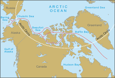
Northwest Passage Map: The red lines are possible routes that ships can use to traverse the Northwest Passage, a shipping route that connects the Atlantic Ocean to the Pacific Ocean through the Canadian Arctic. Geology.com/MapResources
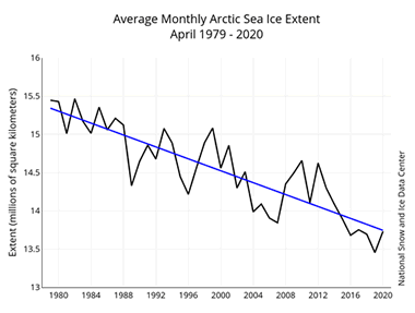
Graph of arctic sea ice extent: Time series graph of the average monthly Arctic sea ice extent in millions of square kilometers. The average January ice extent for 1979 to 2014 shows a decline of 3.2% per decade. Credit: National Snow and Ice Data Center.
What Is the Northwest Passage
The Northwest Passage is a sea route that connects the Atlantic and Pacific Oceans through the Canadian Arctic Archipelago. In the past, the Northwest Passage has been virtually impassable because it was covered by thick, year-round sea ice. However, in recent years, climate change is allowing commercial traffic to pass through the Arctic via this once-impossible route.
The benefits of a clear Northwest Passage are significant. Ship routes from Europe to eastern Asia are 4,000 kilometers (2,500 miles) shorter. Alaskan oil could move quickly by ship to ports in the eastern United States. The vast mineral resources of the Canadian North will be much easier and economical to develop and ship to market
Arctic Sea Ice is Melting
There has been a progressive, year-by-year decline in the thickness and extent of Arctic sea ice. The graph on this page shows how the extent of Arctic sea ice has been on a steady decline between 1979 and 2020.
NASA studies have shown that the extent of Arctic sea ice is declining at a rate of several percent per decade. As the ice cover is removed, solar radiation penetrates the water and warms it, instead of being reflected from the white ice.
Another factor that contributes to warming of the Arctic Ocean is the increase in discharge rates of rivers draining Europe and Asia. These freshwater rivers now receive increasing runoff from melting glaciers. This runoff is much warmer than the Arctic Ocean water. The net result is a slight warming of the Arctic Ocean waters and a dilution of salinity.
Northwest Passage Map
The map at the top of this page shows possible routes through the Northwest Passage. Ships traveling west would enter the Passage through Baffin Bay, pass through the Canadian Arctic Archipelago by various routes, exit into the Beaufort Sea and then out into the Pacific Ocean through the Chukchi Sea and Bering Sea.
During the past few years, satellite images taken near the end of the Arctic summer often show that large portions of the Passage are relatively ice-free. In September, satellite images show that the Arctic Ocean has been clear enough to sail straight through the Northwest Passage.
Early History of the Northwest Passage
The economic value of a short route connecting the Atlantic and Pacific Oceans was appreciated early. The Spanish referred to this route as the "Straight of Anián," and Francisco de Ulloa started searching the Baja California peninsula area for it in 1539. English explorers, including Martin Frobisher, John Davis, and Henry Hudson searched for it from the Atlantic side in the late 1500s and early 1600s. These expeditions were unsuccessful.
Explorations continued through the 1600s and 1700s without success. Then in 1849 Robert McClure passed through the Bering Strait with the intent of sailing through to the Atlantic. His ship was trapped in the ice not far from making it to Viscount Melville Sound and probable passage to the Atlantic. Finally, after spending three winters on the ice and some members dying of starvation, McClure and crew were rescued by a sledge party from one of Sir Edward Belcher's ships and transported by sledge to the Sound. McClure and his crew became the first to survive a trip through the Northwest Passage.
Norwegian explorer Roald Amundsen and his crew were the first to cross the Northwest Passage entirely by sea in 1906. Although the crossing was an important "first," it had little economic value because the journey took three years and used waters that were too shallow for commercial shipping. The first single-season trip through the passage was by Henry Larsen and crew in 1944. Again, the route taken was not deep enough for commercial shipping.
Future of the Northwest Passage
Commercial use of the Northwest Passage might be a small benefit of climate change. Billions of dollars in transportation costs could be saved each year if the passage remains open and reliable for a few months of the year. There will also be time and energy savings. Canada has the most to gain should the Northwest Passage become a viable shipping route. This will facilitate Canada's development of northern lands and provide an important economic and military possession if their claim to control is upheld.


Comments
Post a Comment